Search This Blog

Wednesday, May 3, 2023

San Francisco surprises

 Recently, I went to San Francisco to visit my daughter. She has been living there for three years, but recently got her own apartment and needed some help furnishing, decorating, assembling, and asked me to come visit her. She obviously didn’t want to spend the whole five days with her mom so I contacted an old friend and made plans to get together with him and anyone else he knew in the bay area who could show up. As it turns out when it came time to go, my daughter wanted to go with me, but she invited two friends who had also graduated from Middlebury College. It ended up being six of us at Trader Sam’s in San Francisco. Three alum from the class of 2017 and three from class of 1987.  We started with the scorpion bowl to break the ice.  This turned out to be a great decision!  We were all sharing straws and drinking out of the same bowl!!  This was a big culture shock for me because not only am I not much of a drinker, but I haven’t done anything like this since decades before Covid. Covid did make me more aware of close contact with other people though. It was so much fun. We all threw caution to the wind, and really enjoyed ourselves the entire night.   The three of us from 1987 were all swim team alum. We have a lot in common and we had a lot of fun that night.  And we had fun with the “kids“ although it might have more relaxed and crazier if it had been just us adults. I had to be a mom the whole night for the most part. A lot of pictures were taken, phones were passed around so other people took pictures, quite a bit of alcohol was imbibed even after the scorpion bowl, and there are a lot of pictures to document the fun and shenanigans. My two friends from Middlebury are the two people you would want to invite to any party to make sure that it was a blast. And they did just that. And after quite a few drinks, the kids decided they were hungry, so we wandered down to Clement Street to look for a restaurant. The closest one we found was not one that made me happy but I was outvoted, and as it turned out, I really enjoyed the food and we had a fun night there as well.  Map of San Francisco Adventures

I went back to San Francisco again less than 2 weeks later.  This time I swam in the outdoor pool every other day.  It was 100 feet long (33 and 1/3 yards long). I did not know this at first and my stroke count was 30/length instead of my usual 24 so I thought I was just weak and out of shape.  I started each length feeling great, swimming well and fast and smooth but by the time I got back to the same wall, I was looking and feeling rough.  I rested a lot and as a result I made a lot of friends. I was swimming in the fast lane which was full of old college swimmers like myself.  Everyone chatted and introduced themselves.  There was Scott and Kevin and Brian, there was marathon girl and lot of other names I can not remember  The air was so fresh and the sun and smell of flowers.  I swam 4 times and by the end, my rest periods were much less frequent. I swam for 1.5 hours usually and went longer every time.  I did 72, 94 lengths, 104 and 114.  By the last day, I needed much less rest and the last 3 days I did one legnth of butterfly!  Now that I am home, I really miss swimming.  It is too cold in the lakes at this point and swimming in a dirty indoor pool with chlorine gas all around sounds gross.  But I made so much progress! I can feel the muscles in my shoulders/lats.

I was also intrigued by a class at Laci's that was given during this second trip to San Francisco.  Beetle wing embroidery!  It was very interesting and nice to be in a class with like-minded people.  Laci's has asked me to teach bobbin lace there so it was good to see the teaching space.  It is a great space and the shop museum is wonderful too!  So much to see there, I see something new each time and it is only a half hour walk from J's.

I did some fantastic hikes on my own also:  Reinhardt Redwood Preserve.  This was disappointing.  No really big trees and it is a pretty small area but still nice.

The Volcanic Preserve was more interesting. Very cool terrain and views.  Also not that big.  Both of these areas seem to have been quite encroached on by homes.  The homes are on the sides of cliffs with fantastic views but seems dangerous in earthquake country....

Friday, March 19, 2021

48 4000' stats and thoughts and future plans

 28 individual hikes to complete the 48 4K peaks.

I started Sept 26, 2020 with Jackson and Pierce as my first peaks. 1 hike. 9 miles, 3100 ft elevation gain

In  October I did 6 hikes for 9 peaks

In November, 5 hikes for 8 peaks

In December, 3 hikes, 5 peaks, 23.8 miles, 8163.20 elevation gain

January, 6 hikes, 10 peaks, 56.5 miles, 21,337.4 feet elevation gain

February, 5 hikes, 6 peaks, 53 miles, 16,762 elevation gain

March, 2 hikes, 8 peaks, 34 miles, elevation gain 10,780 ft.


Next winter I hope to complete my Winter 48 by redoing the 20 peaks I did during the fall of 2020.  As I started out with the easier hikes, this should be easier than this year, although there were some hikes we did in the fall purposely while the roads accessing them were still open.  I will have to see which ones will have closed roads and hope I can get in 1-2 before they close.  Otherwise I will ski in where possible.

Zealand, Hale and Osceola come to mind first.

Carters to Wildcats March 17, 2021 #s 44-48!!


 I had a few goals and I accomplished them all.  I wanted to finish the 4000 footers in under 6 months and by the end of winter.  This hike accomplished both of those goals.  The past weeks of cold and extreme wind tried to stop me, but a great weather day came up and I took the day off from work to make it happen.  The third goal was to finish them alive and in one piece.  The 48 4000 footers have many places for disaster to happen.  This I think is also an attraction, the danger.  Not everyone could do this.

Yesterday Dan was nice enough to help me drop off my truck at Wildcat Mountain, then drop me off on Route 16 at the Camp Dodge Rd.  Actually, we dropped the car off first, used the truck to get to Camp Dodge Rd as we were unsure the state of that road, and then he drove back to Wildcat to swap vehicles.  As it turned out, Camp Dodge Rd was closed off with a gate, but did have just enough room to pull off of the highway there, and although it was plowed occasionally, we were glad we took the truck with its high clearance and 4WD.

The weather was gorgeous.  A clear sunny day and blue skies.  The temps soon had me with no jacket on and no mittens or gloves either.  I took the Imp Connector to South Imp trail starting at 10:15 am and did see a man coming down this trail, as I was about 1/2 way up it.  This trail was beautiful.  Gorgeous views of the presidentials, never too steep but enough so I knew I was climbing, earning my peaks.  Most of the ridge trail from Carter to Carter was thoroughly enjoyable with intermittent amazing views to both sides, the Prezzies to the west and Maine (Caribou Wilderness?) on the east. The sun made the exposed rocks glisten. I love ridge trails the best.  I felt like I was getting an easy ride to my 48s until the ascent to Carter Dome.  I chose not to do Mt Hight.  (Gotta leave some peaks for later, right?)  First, it was .1 mile shorter and I figured less elevation would be good, but it turned out to be a sidehill.  Very uncomfortable with unstable down support with steep drops and my snowshoes were constantly building up big snowballs which were uncomfortable with worse footing and annoying so this part was slow going.  Did I forget to say that I wore snowshoes this whole hike?

That sidehill was soon forgotten when I saw the chasm I had to get down from Carter Dome.  The snow was deep and sticky-slick, with lots of post holes, and many times I fell and slid down.  Rocks were sticking up and the cliff was on the left side for most of this .3 miles. This entire descent was a mile but I think only the last .3 was the crazy part.  I tried grabbing trees to slow my descent but on one I had to let go as I felt my arm would break.  It is still in pain today from this event.  I used some postholes as brakes but this was dangerous as it could be leg breaking.  This part was long!  Even Doggo Chuck cried for a second when he postholed.  He was very nervous about me and he is usually up ahead of me scoping the trail out for my safety but he stayed with me for this part because he saw that I was having a hard time and that I was many times out of control, careening down the trail, trying not to break anything or go off a cliff. The views were amazing though.  Oh, and at the bottom, I realized I had lost my empty water bottle. The one Torre had given us for Christmas that had an attached water bowl for my Chuckles.  I was unable to give poor Chuck any water until we got back to the car.

At the bottom of this hill was a small frozen lake with a bailout option.  I seriously considered it.  I have never considered bailing before.  But it was 3.2 miles to the highway and then some amount of miles back to Wildcat, so, as treacherous as the up might be to Wildcat A (I had yet to see it) and as traumatized as I was from coming down from Carter Dome, it was only about 2.5 miles to the top of Wildcat D so I took that route.  Also, 2 women hikers are currently missing in the area so maybe there's a bad guy out there.  He will have a harder time finding me out in the woods.  I have not seen another person since a mile or so in, and he was the only one I had seen!

So I began the up.  Luckily it was getting cooler and darker in the shade of Wildcat so the snow was not balling under my feet.  The sun had set in the valley but it was mostly super steep sidehills that had only very narrow footholds.  In places, I had to walk sideways with my toes the only thing on slippery snow that was giving away down the hill.  Up for .7  and super steep.  I just had to keep going and not fall down the cliffs.  Once up on Wildcat A, I realized I was safe and the rest of the hike was pretty normal, just under 2 miles to my final peak.  I was actually telling myself over and over that I was OK and the hard part was done.

I arrived on the top of Wildcat D at about 7:15. Chuck got there a bit earlier.  There was some kind of structure there, with solar panels and a porch, but I still could not see the slopes so we continued south on the trail a bit more until we saw the slopes and the ski patrol hut.  Chuck loves open fields and there was not a soul around.  The ski slopes had been closed for over 3 hours at this point.  We headed back towards the north towards Polecat trail/slope.  Under a sliver of a moon, with a headlamp, we walked and sledded down. We felt like we definitely took the long winding way down.  We passed a young couple hiking up with skis.  They were surprised but charmed to meet Chuck.  We finally made it to the bottom only to wander around looking for the parking lot.  What I would not give to see my truck.  We did finally find it, and it was the only vehicle in the parking lot at 8:00pm.  I never thought this hike would take me 10 hours!  Dan had reparked it there so I did not know exactly where it would be although we discussed where it would be roughly.  First row as close as he could get to the slopes.  We took the 1-3/4 hour drive, no phone service for some reason until I hit my home WiFi.  I was not so sore from this hike, other than my arms, especially my right arm, from trying to grab trees while hurtling downhill out of control.  This was the most technically difficult hike we have done I think.

Oh bed, sweet bed. I could not believe I had made it back to my bed, successfully.  Peace and success!  During the hike, the book I was listening to (Bookmarked for Death, by Lorna Barrett, pure entertainment but local NH entertainment) had a lot of pastries and cakes described so I thought I would have some ice cream when I got home but I was too tired to eat, and I had felt nauseous towards the end of this hike and the Bonds, so I just had a couple oranges and yogurt and went to bed.   Chuck was happily snoozing in bed although as usual, he sleeps hard as soon as he gets in the back seat of the truck after each hike.


Thursday, March 11, 2021

Bondcliff, Mount Bond, West Bond, #41-43!


 On Wednesday, March 10, I took the day off from work to do this hike.  22.2 miles was certainly daunting so I wanted perfect weather conditions and I needed to heal all my soreness from Adams and Madison, which was the sorest I have been from a hike (thanks to the speed I got from Queen's "Don't Stop Me Now!") The place on my butt that hurt from hitting a big ice chunk on Vally Way was still sore so I did not bring a sled.  I could barely sit down still, let alone sled.

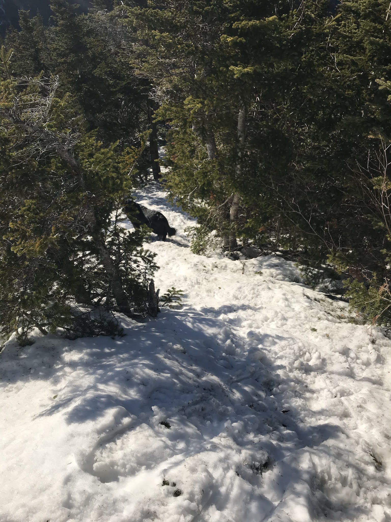
I had tried to leave my house at 6:15 but did not end up getting out until about 7:00 am.  This hike's book time is 12.5 hours and I did not want to be too long in the dark.  I ended up beginning at 8:00.  I started on XC skis, for the first 5 miles.  The trail was super icy and this was not an advantage.  There were others walking and I was not really faster.  I had to keep taking my skis off and putting them on for water crossing, steep hills to bridges etc.  After 2.9 miles the going got tougher and I thought maybe I should have left my skis there as the trail was narrower and windy but I also needed to leave them somewhere I would remember and find them so I kept going, until I had gone a bit onto the BondCliff trail.  The narrow trail was the only place that you wouldn't sink up to my thighs so I could not even stash them. I left them on the side of the trail with my ski boots in a plastic bag next to them.  Would they still be there when I returned?

I have not done much XC skiing at all this winter as all of my time has been devoted to hiking and recovering from hiking.  On this past Sunday I skied a bit on the lake, and my inner thighs and other places were sore from the short effort.  I knew this did not bode well for 10 miles of skiing on this hike but it was too late to do anything about that.

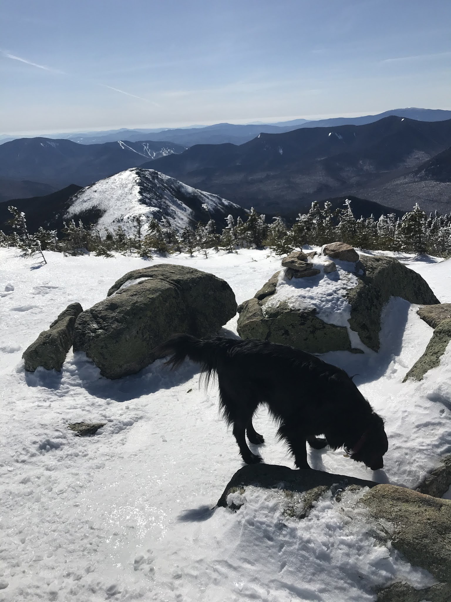
As I started the hike up Bond Cliff, I told myself it was only 4 miles to the first peak.  Breaking down the hike in doable chunks helped.  There were some steep places and sidehills but overall this is not too bad of a hike other than the sheer distance (22.2!).  I passed a man coming down and a man going up (who I surprisingly never saw again!)  Neither one looked like they would fit in my ski boots.  The views from BondCliff were outstanding!  Bond, however, looked farther away than I had expected, but Marlene says they always look farther than they are.  There was nothing for it but to keep going.  Now I told myself 2 miles to the turnaround point.  I can do 2 miles, right?  The hike above treeline was very shiny icy immediately off the narrow tread path.  Thank goodness there was a broken trail.  It was quite steep up to Mount Bond but not the worst I have ever seen.  Once there, we looked around but then kept going to West Bond.  This trail, between Mount Bond and West Bond, would have been good for snowshoes, but I was already carrying enough with the ski equipment (not now) so I had not brought them. It was totally doable but the snow was softer, deeper, and in the trees. Even had I brought them, I probably would not have taken the time to change into them, so I made the right decision.  

Once on the West Bond trail, I could not believe how far away and how high West Bond's peak was.  Surely that glimpse I had of it was really a farther-off peak?!  But it was only .4 and then I made it halfway.  The views were amazing.  Did I mention that there was barely a cloud in the sky?  There was some wind, but I did not even need to wear a jacket, hat nor neck warmer for this entire hike.  A lot of the time, I did not even wear mittens or gloves!  I did pass some boys on the way back who were bundled in hoods and goggles so maybe it was me?  I do not think so.

11.1 miles.  I was tired and sore and had bagged the 3 peaks, but I still had to get back.  A helicopter seemed like a nice daydream. But onward ho, every step was a step closer to the end now.  From when I had gotten in the car, I was listening to an audiobook:  Life After Life by Kate Atkinson.  Slow going but makes more sense the more I listen. I thought of just quitting this book.  What is the point?  I will have to give it some thought but no energy for thought now. At this point, I knew my phone battery was not going to make it the whole hike but I needed some energy.  I tried to sing my new favorite Queen song while listening to the book but that did not really work.  I was too lazy to stop and change to tunes.  The uphill to Bond was tough. I had blisters on the back of my ankles.  Probably started because my minus 33 socks are too big but maybe there is something worn in the back of my boot?  I changed my socks.   I will have to check the back of my boots.  Later. On downhills, the bottom of my boot is sliding forward, is that a toe blister forming?  This is the hardest part, once I get to Bond Cliff it will be all downhill or flat from there, must keep going.  I never thought but I peaked 5 mountains today!  Bond and Bondcliff twice each!  Coming down from Bond should be illegal!  Steep, on the side of a cliff, icy!  You must stay on the narrow path or death. Although sinking down deep as soon as you step off might save your life while you break your leg.  How do you get down if you are injured?  Do a lot of people have to be rescued from here?  In between Bond and Bondcliff, some nice boys bundled in hoods and goggles! stepped aside to let me go by and I fell right in front of them!  lol

Coming down from Bondcliff was only 4 miles. (could I make it under 40 minutes...no) I ran quite a bit of it.  I did not run the narrow side of the cliff trail,  in some places only 6 inches wide and I could see where a lot of people stepped a bit wider and fell down into a deep post hole. I did change to music here for a short while as I needed the energy but my phone died somewhere on this section.  The short slight uphills killed the blisters on the back of my heels, I could avoid them when going downhill.  I fell more than I can count, by running and then post-holing far down, but the landings were thankfully soft.  I was in so much pain at this point.  I barely ate on this hike and I could not bear to eat at all at this point. I maybe ate 1 egg with a bit of cheese and bacon and only a few dried mangoes.  This was the first time I took dried mango, or anything other than egg bacon and cheese. I thought the sheer distance would necessitate some more food but no.  I was shaky and dizzy.  Where the hell was the end of this 4-mile stretch and my skis?  It went on and on.

I finally found my skis right where I left them.  It was hard to change my shoes, bend over and I wanted to throw up. Skiing back seemed faster than coming in.  The snow had softened, not so icy. I was faster than walkers! I still had to take the skis on and off occasionally and I was so stiff sore and awkward I could barely ski but I was making progress!  The last 3 miles of the ski were firmer so I could pole, although many times my poles stuck hard and fast and I had to fight to get them back. I fell a few times too. Especially in the first 2 miles where the poles were useless. The first 2 miles made my arms and wrists hurt from my sinking poles.  The last 3 miles would have been fun if I was not in so much agony.  Sometimes I could even just pole or just stand there.  There were a few uphills too.  It was hard work and seemed like 10 miles but I finally made it back to my wonderful truck.  I drove home but this was definitely impaired driving.  Surprised I did not get pulled over and breath tested.  Had I had to get out of the truck and walk I would have failed.

Start: 8:00

BondCliff trail started at 10:00

Bondcliff peak at 12:30

Mount Bond summit at 1:08

West Bond summit at 1:58  Stopped to eat

Mount Bond summit at 3:00?

BondCliff summit at 3:45

Bottom of Bond cliff trail: 4:45.  Wish I had taken a pic of my skis, for posterity and time stamp

talked to some people coming off Owls Head and some people I had seen in the morning.  Did not see them on Bonds so maybe they did Owls Head too?

Back at the truck: 6:00  Home at 7:00, took the bread out of the freezer, put my homeade chicken veggie soup on the stovetop, hot tub, dinner, painful bed, too tired for snacks or dessert.

Total time 10 hours.  Book time 12.5

I basically did a triathlon of skiing, hiking, and running.  This felt kind of good to use different muscles but made me more tired and sore since everything hurt.  However, recovery seems faster as no muscles were taxed as much as they would have been.  Coming down I decided I would not do my Carter's to Wildcats traverse as I will never hike again, but now, not a day later, I know I will. Maybe in 3 days as the weather looks best on Saturday.  Will I be recovered enough to do so?

Thinking about the Bonds now, I realize that this view will forever change me. And to know that I am capable of anything. All by myself. I am strong and determined. 

I love driving now. I am more aware of the mountains than ever. Their enormity and I recognize them. Once you hike their contours, you can recognize them. Even from a distance. 

I read somewhere recently that awe is a more powerful cure than any drug from anxiety. And since they’re two sides of the same coin, depression too. Now I better understand people who spend so much time in the mountains. Self medicating. I think it’s medicine for everything. The earth heals